Shifting Victoria's emphasis in land-use planning for bushfire: Towards a place-based approach
Dr Lucy Groenhart, Dr Alan March, Mark Holland
Peer-reviewed Article
Abstract
Article
Introduction
The role of land-use planning in reducing bushfire risk is increasingly being recognised both in Australia and internationally. The 2004 COAG National Inquiry on Bushfire Mitigation and Management found that land-use planning processes to ‘ensure that built assets are not placed in areas of high fire risk’ (Ellis et al, 2004) were a key risk mitigation measure for bushfire in Australia. Planning has again come to the forefront of bushfire policy following the 2009 Victorian bushfires, one of Australia’s most devastating natural disasters. This event caused the death of 173 people and property damage estimated at $4 billion (Teague et al, 2009). The Victorian Royal Bushfires Commission (VBRC), established to enquire into the fires, made 67 recommendations of which 19 related to planning and building controls. These included that the State ‘amend the Victoria Planning Provisions relating to bushfire to ensure that the provisions give priority to the protection of human life’ and ‘adopt a clear objective of substantially restricting development in the areas of highest bushfire risk’ (Teague et al., 2009). The Victorian Government accepted all of the VBRC’s recommendations. Handmer and Haynes (2008) suggest that Victoria has taken a lead in terms of developing planning instruments to mitigate fire risk. Discussion here partly explores this proposition by looking at recent changes to the Victorian planning and building system, and considering them against the broad principles of place-based planning for disaster management.
Place-based planning and risk
Urban planning is concerned with finding ways that human settlements and natural systems can be spatially and functionally arranged in the most advantageous way (Hall 2007). While this is a highly complex task, one aspect that planning may take into account is the management of risks associated with hazards, such as bushfires. Risks are widely defined as the ‘effect of uncertainty on objectives’ (ISO 31000, 2009) – in this case the possibility that bushfires may take human life, damage property, or impact the environment, economy or social functions of places in a given fire season.
Mapping of the bushfire hazard
In keeping with a place-based approach, integrating risk with planning processes highlights the site-specific and highly varied nature of bushfire risks. Place-based planning identifies the specific physical, natural and human values of a given geographic area and the ways we ‘make’ places (including the bushfire risks they face) by the ways we build, live in, and manage them (Tuan, 1977). In this sense, a place-based planning approach to bushfire ensures that risks associated with a given place and planning proposals are explicitly considered. Planning should consider the particularities of bushfire risk on sites in their context (Schwab et al, 2005), at various geographic scales, and over longer timeframes such as those required to consider fully disaster risks (Alexander, 1999).
The Bushfire Integrated Planning and Building Framework
In response to the VRBC recommendations, the Victorian Government developed a Bushfire Integrated Planning and Building Framework to ‘strengthen the consideration of bushfire at different stages of the planning process and better integrate the planning and building systems’ (Victorian Government, 2011a). The principal changes introduced by the Framework are:
- a new emphasis on the priority of protecting human life in building and planning decision-making, and
- the application of the precautionary principle to development in areas at most risk from bushfire.
The emphasis on protecting human life is a shift from the previous policy outlined in the Wildfire Management Overlay (WMO). This stated that new development should ‘not significantly increase the threat to life and surrounding property from wildfire’ (Victorian Government, 1997, emphasis added).
At a state-wide macro scale, new mapping of the bushfire hazard has been carried out for the Bushfire Management Overlay (BMO). The BMO came into force in November 2011 and replaced the WMO. Under the WMO, mapping of bushfire risk was based on areas of forest greater than five hectares in size and with a vegetation density of greater than 80 per cent. The BMO mapping is based on a more detailed set of criteria, including vegetation, weather characteristics and slope (see Figure 1). The Victorian Government is currently working with local councils to finalise the updated BMO mapping.
Figure 1. Victoria Bushfire Prone Areas are in orange and Bushfire Management Overlay areas are in pink. Source: Department of Planning and Community Development, 2011.

A multi-tiered location specific response to bushfire risk
The BMO is part of a new multi-tiered location specific response to bushfire risk, with site based response levels increasing as bushfire hazard escalates, as shown in Figure 2.
Figure 2. Location specific response to bushfire risk. Source: Department of Planning and Community Development, 2011.
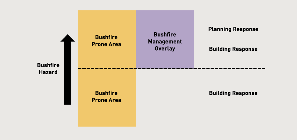
- Low-risk areas are outside the BMO and Bushfire Prone Areas and require no additional response. These are generally built up, urban areas that do not connect with the bushfire hazard, including ember attack.
- Bushfire Prone Areas are subject to, or likely to be subject to, bushfires as designated by the Victorian Minister for Planning. They cover the majority of Victoria, including grassland and farming land (see Figure 1). Development of land in BPAs has specific building requirements under the Building Code of Australia. An assessment of the site is required to establish a Bushfire Attack Level (BAL) to determine construction requirements (see Table 1). In establishing a site’s BAL, the Fire Danger Index, vegetation type, distance of the site from vegetation and the slope of the ground under the vegetation are taken into account. Once the BAL is determined (from ‘Low’ to ‘Flame Zone’) construction requirements are set out for things like flooring systems, external walls and doors, windows, and decks. As the bushfire threat increases, so do the construction requirements.
- Land in the BMO covers a smaller area than the BPA (see Figure 1). This is considered to have the highest bushfire risk. Both building and planning responses now apply to development on this land. Based on the site assessment approach used by the Australian Standard AS 3959-2009 Construction of buildings in bushfire prone areas, the BMO shows the defendable space, construction requirements, water supplies and access requirements that must be maintained for the life of the development.
This is the practical realisation of the Integrated Planning and Building Framework.
Table 1. Bushfire Attack Levels and corresponding construction sections within the new building standard.
|
Bushfire Attack Level (BAL) |
Description of predicted bushfire attack and levels of exposure |
|---|---|
|
BAL – LOW |
There is insufficient risk to warrant specific construction requirements |
|
BAL – 12.5 |
Ember attack |
|
BAL – 19 |
Increasing levels of ember attack and burning debris ignited by windborne embers together with increasing heat flux between 12.5 and 19 kW m2 |
|
BAL – 29 |
Increasing levels of ember attack and burning debris ignited by windborne embers together with increasing heat flux between 19 and 29 kW m2 |
|
BAL – 40 |
Increasing levels of ember attack and burning debris ignited by windborne embers together with increasing heat flux with the increased likelihood of exposure to flames |
|
BAL – FZ |
Direct exposure to flames from fire front in addition to heat flux and ember attack |
Place-specific assessments
Development proposals in BMO areas are subject to both building and planning controls. Planning controls require applicants who want to subdivide or build to complete a number of place-specific assessments, starting with the broader landscape. The proposed development must be described in its landscape context, including:
- characteristics of bushfire hazard in the local area
- likely bushfire behaviour
- proximity to established urban and town areas, and
- access and egress arrangements.
At the site scale, there are new standards for locating buildings to achieve better bushfire resilience and minimise vegetation removal.
Based on Australian Standard AS 3959-2009 the requirements include a revised method for calculating defendable space. Defendable space is ‘an area of land around a building where vegetation is modified and managed to reduce the effects of flame contact and radiant heat associated with bushfire. It comprises an inner zone and an outer zone’ (Victorian Government, 2011b). This space must be located on the site itself and it can incorporate land that does not require management to minimise the spread and intensity of bushfire. There also must be some certainty that it will be managed in perpetuity. Table 2 provides the basic level of management required for the inner and outer zones.
Table 2. Inner and outer protection zone requirements.
|
Zone |
Requirements |
|---|---|
|
Inner protection zone |
|
|
Outer protection zone |
|
|
Inner and outer zones |
|
Development must achieve defendable space and the new system provides the process for that determination. Once this is established, the appropriateness of any vegetation loss and the requirement to ‘offset’ that loss is considered under the relevant sections of the planning scheme.
Local overlay schedules
A further aspect of place-based planning is the introduction of local overlay schedules to the BMO. These provide bushfire protection requirements to be tailored to specific local circumstances. A schedule can address a particular neighbourhood, township or rural settlement and may specify alternative standards and permit exemptions that respond to local conditions. These were not allowed under the WMO.
Refusing applications
There is now a clear framework for refusing subdivision or building applications under the BMO on the grounds of bushfire risk. The BMO’s objectives and standards provide a benchmark for meeting policy objectives and determining ‘acceptable risk’.
With the new emphasis on the priority of protecting human life in building and planning decision-making and the application of the precautionary principle to development in areas at most risk from bushfire, applications for subdivision permits must ensure new lots in bushfire areas meet bushfire protection requirements and are capable of being built upon. There will be situations where the objective of protecting human life cannot be met, for example if acceptable defendable space cannot be established. In this case, development would be refused.
Finally, Victoria’s new planning provisions remove the need for a planning permit to clear native vegetation around existing dwellings for bushfire protection. For land in the BPA, the ‘10/30’ vegetation removal rule allows vegetation including trees within 10 metres from an existing dwelling, and other vegetation (except for trees within 30 metres) to be removed. For land in the BMO, a ‘10/50’ vegetation removal rule extends the ‘as of right’ removal of vegetation (excluding trees) to 50 metres from a dwelling. This allows landowners to create more defendable spaces on their site without a permit.
Discussion and conclusions: towards a place-based approach?
The recent roll-out of the Bushfire Integrated Planning and Building Framework in Victoria includes a number of elements and is a significant step forward in terms of reducing bushfire risks. It includes place-based planning that begins to harness urban planning mechanisms to deliver site-specific responses to disaster risks. This is quite different from the one-size-fits-all mechanism. The explicit prioritisation of human life in the planning provisions provides an overall standard against which decisions can be measured. This is important in decreasing the tendency for compromise via development control processes which try to balance out multiple concerns. The ongoing implementation of mapping to identify bushfire hazard areas is a key step in developing a knowledge base at the various spatial scales necessary for informed decisions regarding which level of requirement should be applied. Detailed decisions are made following a site assessment.
The direct integration of building standards with land-use planning mechanisms, allows a more sophisticated and streamlined approach. This draws direct attention to determining, for a given location, the combination of building, design, vegetation or planning responses required to reduce risk to an acceptable level. The use of a tiered mechanism for determining risks using a spatial and site specific basis is fundamental to this approach. It draws the core elements of planning and disaster risk management approaches together.
The recent policy developments in Victoria also suggest a number of additional directions for future research and policy development. The first relates to the interplay of bushfire risk reduction and strategic planning processes. Continuing growth pressures and the desire for land owners to develop and use land in attractive and sometimes lower-cost locations at the edge of settlements or in remote areas, will continue. Accommodating this growth now requires that an assessment regarding acceptable bushfire risks be made and prioritised against the range of other goals. These goals include:
- housing choice and affordability
- size of rural lots, and
- the scope for individual choice.
The second direction relates to the range of policy measures aimed at improved ecological management, such as the Commonwealth Environment Protection and Biodiversity Conservation Act 1999, the Victorian Flora and Fauna Guarantee Act 1988, and components of the Victoria Planning Provisions relating to protection of native vegetation and habitat, or of amenity. Balancing these competing objectives is challenging. It is most successful when considered as part of robust strategic planning processes, rather than at the development application stage where siting constraints can lead to choices between prioritising human life, vegetation retention, or sterilising land from development.
The Victorian Government policy is now clear: protecting human life must be prioritised. Adequate strategic planning is crucial so that broader planning requirements, such as zoning, satisfactorily reflect bushfire risk. Planning requirements should not create the expectation that urban growth or intensification of land-use is appropriate where it is difficult or unreasonably expensive to achieve development objectives as well as protect human life.
The majority of Victoria’s existing settlements were constructed well before planning and building controls sought to manage bushfire risks. Victorian planning, like its other Australian equivalents, is strongly oriented to passive regulatory standards focussed on management of change initiated by landowners seeking to develop. This raises the question of whether there is a need for more comprehensive complementary measures that actively intervene in high risk areas to reduce bushfire hazards. The possible shortfall of appropriate expertise is highlighted by the range of skills necessary to manage bushfire risks adequately, and with due regard to other considerations such as maintaining aesthetic and ecological values. These include, but are not restricted to, urban planning, building engineering and surveying, fire engineering, fire behaviour and science, forestry, landscape architecture, urban design, and bushfire emergency response.
References
Alexander, D. E. (1999). Natural Disasters London, Kluwer.
Ellis, S., Kanowski, P., and Whelan, R. (2004). National Inquiry on Bushfire Mitigation and Management. Canberra: Commonwealth of Australia.
Handmer, J., Haynes, K. (2008). Community Bushfire Safety. CSIRO Publishing, Canberra.
Hall, P. (2007). Urban and Regional Planning. London, Routledge.
Hughes, R., and Mercer, D. (2009). Planning to Reduce Risk: The Wildfire Management Overlay in Victoria, Australia. Geographical Research, 47(2), 19.
ISO (2009). AS/NZS ISO 31000:2009: Risk management - Principles and guidelines Standards Australia.
Schwab, J., S. Meck, and Simone, J, (2005). Planning for Wildfires. Planning Advisory Service Report. Chicago, American Planning Association.
Teague, B., McLeod, R., and Pascoe, S. (2009). Victorian Bushfires Royal Commission Final Report. Melbourne: Parliament of Victoria.
Tuan, Y. (1977). Space and Place. Minneapolis, MN, Minnesota University Press.
Victoria Planning Provisions: Wildfire Management Overlay, 13.05 C.F.R. (1997).
Victorian Government. (2011a). Planning and building for bushfire protection. Melbourne: Department of Planning and Community Development.
Victoria Planning Provisions: Bushfire Management Overlay, 44.06 C.F.R. (2011b).
About the authors
Dr Lucy Groenhart is a Research Fellow in Environment and Planning, School of Global, Urban and Social Sciences at RMIT University, Melbourne.
Dr Alan March is a Senior Lecturer in Urban Planning, Faculty of Architecture, Building and Planning at The University of Melbourne. Allan is the lead guest lecturer for the “Risk-based land-use planning” program conducted regularly at the Australian Emergency Management Institute.
Mark Holland is the Community Safety Officer for the Country Fire Authority, Victoria.