The first step in understanding risk is understanding the hazard. This means knowing the likelihood of the hazard event and its intensity. During 2018, Geoscience Australia updated the Tropical Cyclone Hazard Assessment (TCHA) to better calculate the likelihood of tropical cyclones in Australia.
The TCHA contains artificially generated tropical cyclone tracks that gives a realistic evolution of tropical cyclones over their lifetime. The update improves understandings of how cyclones weaken once they make landfall. Information from the TCHA defines the severe wind hazard posed by events based on the frequency and intensity of tropical cyclones making landfall on Australian coastlines. The 2018 update included data on 160,000 tropical cyclone scenarios for 400 locations around Australia.
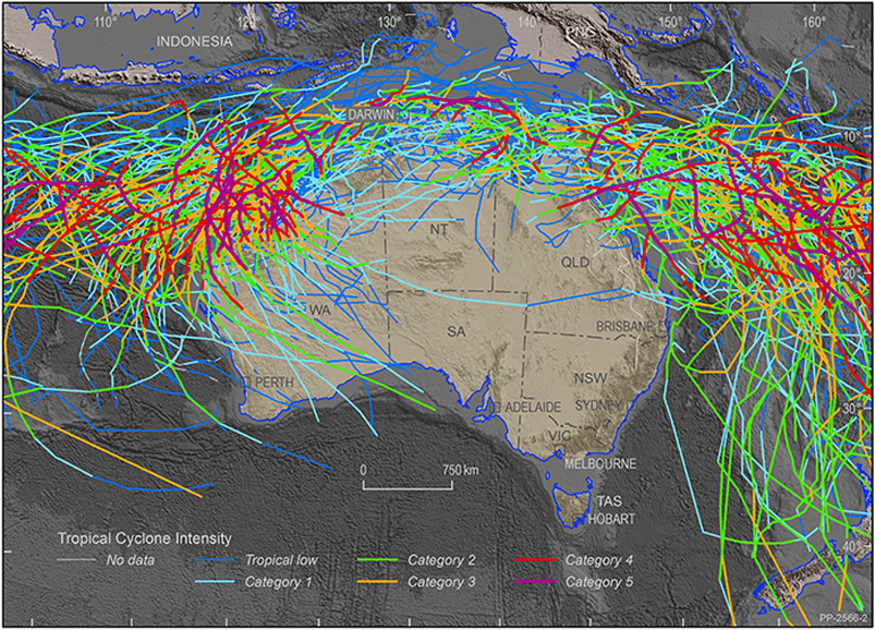
Historical tropical cyclone activity across Australia between 1981 and 2017. Image: Geoscience Australia
The data gained from the update will be used by Geoscience Australia and other organisations to develop cyclone hazard and impact models. This is a step forward for evidence-based disaster management and evacuation plans as well as infrastructure and mitigation planning.
These assessments allow users to apply nationally consistent data to evidence-based disaster risk reduction activities. The TCHA provides vital information to emergency managers, infrastructure owners, town planners and engineers to plan for and reduce the threat of tropical cyclones. It also supports the insurance and reinsurance industry to understand tropical cyclone risk as an input to pricing insurance premiums.
Data from the TCHA reveal that there are no surprises to the regions identified as being at higher risk to tropical cyclone hazard in Australia. For the 500-year average recurrence interval in the building code, the highest hazard area in Australia is along the Pilbara coastline, near Karratha in Western Australia where wind speeds have the potential to exceed 250 km-per-hour, equivalent to a Category 4 tropical cyclone. However, the TCHA shows that, in rare cases, the tropical cyclone hazard area can also extend south as far as Perth as well as down the east coast of New South Wales.
The TCHA is used in Geoscience Australia’s three-year project with the Western Australia Department of Fire and Emergency Services to identify the state’s vulnerability to severe wind events. Four regional centres of Broome, Port Hedland, Karratha and Exmouth were chosen for tropical cyclone hazard analysis. Geoscience Australia will model Category 3 and 5 tropical cyclones impacts on these areas to assess the potential physical damage to buildings and critical infrastructure. In addition, assessments will be undertaken for Perth, Geraldton and Carnarvon to broaden protections for coastal communities.
The TCHA along with the Probabilistic Tsunami Hazard Assessment and the National Seismic Hazard Assessment provides essential evidence-based information to government and emergency managers around Australia to help communities prepare for, mitigate against and respond to natural disasters.