Abstract
The Intergovernmental Panel on Climate Change recently described high-tide flooding as ‘the most urgent adaptation challenge’ (Cooley et al. 2022, p.127) facing coastal communities. However, high-tide flooding hardly features in most Australian coastal hazard assessments. This paper outlines the key findings and implications of recent research on high-tide flooding for planners and emergency managers in Australia.
Introduction: What is high-tide flooding?
In most coastal Australian cities and towns, coastal floods can occur due to high water levels in harbours, bays, estuaries, and tidal rivers. Coastal water levels result from a combination of factors including sea level rise, solar-lunar tides and storm surges. Sustained heavy rainfall can lead to even higher water levels in estuaries, as seen in 2022 in coastal towns in Queensland and New South Wales. Coastal floods in Australia have traditionally been associated with inclement weather including heavy rainfall, low atmospheric pressure and strong winds (McInnes et al. 2016, Callaghan & Power 2014).
However, increasingly, floods can occur without any associated significant weather simply because global mean sea levels have risen and continue to rise (Ray & Foster 2016). Tides are the key feature in determining the timing of these flooding events, which are referred to as 'high-tide' floods. Tides occur due to the gravitational pull of the Moon and the Sun on the Earth's oceans and interactions with the shape of coastlines and the ocean floor. The heights of high tides vary between locations and depend on the time of year. Tides can be accurately predicted years in advance for most locations because they follow regular cycles. They typically reach their highest levels for a few days either side of full moons and new moons.
Recent Australian high-tide flooding data and research
For the last 4 years, the Bureau of Meteorology, in partnership with Monash University, has been studying high-tide flood events in Australia, building on existing work from the United States (e.g. Sweet & Park 2014, Sweet et al. 2018, Thompson et al. 2021, Moftakhari et al. 2015, 2017). Definitions of coastal flood thresholds (Hague et al. 2019), conceptual models for defining high-tide flooding (Hague & Taylor 2021) and a new high-quality tide gauge dataset (Hague et al. 2021) have been developed. These have been brought together into the first national assessment of frequencies and trends in coastal flooding in Australia's major coastal cities and towns (Hague et al. 2022).
Our approach maximises consistency between existing products and services delivered by the Bureau, with a view to eventually supporting operational services and decision-making. For example, minor coastal flood thresholds were defined such that the impacts associated with water levels reaching these thresholds are consistent with those implied by warnings for minor flooding in rivers and lakes. Our high-quality dataset, the Australian National Collection of Homogenised Observations of Relative Sea Level (ANCHORS) uses equivalent methods to the Bureau's temperature dataset, ACORN-SAT (Trewin et al. 2020), with modification to account for the nuances of sea level. These data have been quality-controlled and assessed for artificial factors such as tide gauges being relocated or replaced. The dataset measures changes in relative sea level rather than changes just due to climate and ocean processes ('absolute' sea level). This is because we want to understand how sea levels relate to land heights at different locations to inform the study of coastal flood hazards. Globally, vertical land motion is a key factor that influences coastal flooding frequencies and severities (Karegar et al. 2017). For Australia, this consideration of land motion is less important as variability and change in sea level is generally happening at rates much faster than movements of the land in the coastal zone.
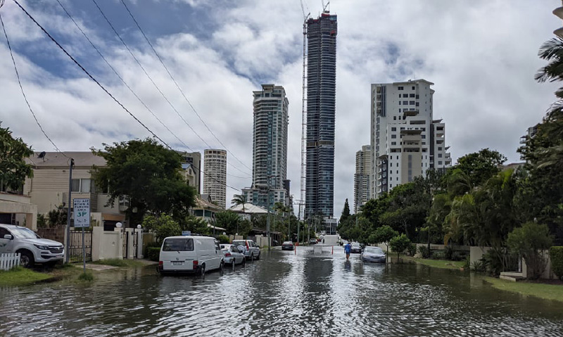
High-tide flooding on the Gold Coast, Queensland in January 2022.
Image: James Thompson
A national assessment of past and present high-tide flood hazards
new coastal flood hazard assessment (Hague et al. 2022) provides the missing link between extreme sea levels and the on-the-ground impacts they cause. This was the first time that spatial patterns and temporal changes in frequencies of coastal floods of common results (in this case, minor flooding) could be described in a nationally consistent way. This enabled the first national assessment of how frequent minor coastal floods are across Australia and how the frequencies of these events are changing as sea levels rise.
Previous regional and national Australian coastal hazard studies have assumed that the coastal floods of concern to planners and emergency managers either occur very infrequently (e.g. once per decade or century), at the same frequency at every point around Australia, or both (e.g. Lowe, Cuttler & Hansen 2022; Pattiaratchi, Hetze & Janekovic 2018; McInnes et al. 2015; Haigh et al. 2014; McInnes, Macadam & Hubbert 2013). Hague et al. (2022) shows this assumption may be less than ideal. For example, the Gold Coast area of Queensland experienced an average of 12 days of coastal flooding per year over the baseline period of 1992-2011. By contrast, Newcastle in New South Wales experienced an average of 26 days per year and Fremantle, Western Australia experienced less than 2 days on average. This shows that not only does high-tide flooding occur frequently in some locations, but its exact frequency also varies from place to place.
Consequences of these floods include inundation of roads and car parks (Hague et al. 2019, 2022), which are associated with negative economic and social outcomes (Buchanan, Oppenheimer & Parris 2019; Hino et al. 2019; Kasmalkar et al. 2020; Hauer et al. 2021). In some locations, high-tide flooding, which might be considered moderate, is now emerging, or soon will emerge with only modest further rises in sea level. This shows that floods that should be of concern to planners and emergency managers can occur more frequently than once per decade or century.
Hague et al. (2022) also showed that while all locations saw increases in coastal flood rates linked to increases in mean sea level, the amount of sea level rise was not a good predictor of how much coastal flood rates increased by. For example, the coastal flood trend on the Gold Coast was 9 days per decade but at Fremantle it was 0.38 days per decade. This difference is despite both locations experiencing the same sea level rise rate of +4 mm per year over the study period.
Towards a national assessment of future high-tide flood hazards
The present best-available coastal sea level guidance for future planning (CSIRO and Bureau of Meteorology 2015) does not capture these extreme spatial variations in how coastal floods rates respond to sea level rise. This is because the coastal risk measure used, sea level allowances, only considers how much higher (i.e. not more frequent) future sea level extremes will be relative to their historical equivalents. Clearly both perspectives are important, but an allowance approach may not be sufficient to capture all dimensions of the current or future flooding risk.
Multiplication factors (Hunter 2012) indicate how much more frequent historical extremes will become in the future. These have been computed for Australian locations and are available via the CSIRO online tool, Canute 3.0 (https://shiny.csiro.au/Canute3_0/). However, multiplication factors use statistical methods that do not represent tidal processes well (e.g. Stephens, Bell & Lawrence 2018; Ghanbari et al. 2019). While this limitation was acknowledged in development (i.e. Hunter 2012), its significance for coastal flood hazard assessments has only been realised in recent years as the effects of high-tide flood events have seen closer scrutiny from scientists worldwide. Various alternative analysis methods that successfully address this shortcoming have been developed and applied in the United States (e.g. Moftakhari et al. 2017, Sweet et al. 2018, Ghanbari et al. 2019, Thompson et al. 2019) and New Zealand (Stephens, Bell & Lawrence 2018) but their adoption is lagging in Australia.
Two studies have made incremental steps towards applying these methods in Australia to understand how the frequency and severity of present-day minor floods will change, but only on local or regional scales. Hague et al. (2020) showed that minor flooding is expected weekly in Sydney by 2050, regardless of greenhouse gas emission scenario. By 2100, events like the current ‘1-in-100-year’ flood level used for flood risk planning will occur weekly under moderate- and high-emissions scenarios. Even under low-emission scenarios, these events are expected to occur multiple times per year.
Hanslow et al. (2018) found that 8,500 properties in New South Wales are currently flooded annually due to tides. Under 50 cm of sea level rise, 23,700 properties are likely to be exposed. This increases to 50,700 properties under 1 metre of sea level rise. Of these 50,700 properties, 14,200 will have more than 90% of their land area flooded during high tide meaning near complete submergence and likely significant loss and damage. Both studies assume an absence of effective future adaptation that reduces or removes flood hazards associated with the present-day minor flood level and no change to the number or placement of existing assets.
These studies show that a national assessment of future changes in the frequency of present-day and historical floods are urgently needed to assess the extent to which high-tide flooding poses a threat. For example, we do not know whether the results from Sydney and NSW are representative of the risks facing Australia as a whole. Given the number of properties that will be regularly flooded under fairly modest sea level rise, there is some urgency to ensure that current and future planning decisions do not add to this burden and, where possible, actively reduce future exposure and vulnerability.
It is quite probable that increasingly frequent high-tide floods, and not increasingly extreme extremes, will be the dominant driver of adaptation in coastal communities (Buchanan, Oppenheimer & Parris 2019). Conventional responses to extreme extremes such as insurance or engineering in the form of tidal barriers, levees or drain sleeves may not be an option for frequent flood risk. Events that happen frequently are likely to contribute to compound events in the future, for example, where riverine and coastal flooding occurs concurrently. By excluding high-tide floods in coastal hazard assessments, we risk omitting the element of the hazard that most affects community-level responses to that hazard.
Conclusion and next steps
Sea level rise will continue after greenhouse gas concentrations stabilise, with rises of many metres possible (Fox-Kemper et al. 2021). Therefore, adapting to increasingly frequent and severe coastal floods is largely a case not if but when. This shows the importance of developing new perspectives on coastal hazards that include high-tide flooding and the triggers that elicit adaptive responses from policy makers and communities (Stephens, Bell & Lawrence 2018). These perspectives need to be considered in new research initiatives and when developing local, state and national dynamic adaptive policy pathways (Haasnoot et al. 2013). This will require collaborative approaches between scientists, policy makers and emergency planners to ensure Australia is best prepared for future responses, challenges and decisions regarding coastal floods in the decades and centuries to come.
References
Buchanan MK, Oppenheimer M & Parris A 2019, Values, bias, and stressors affect intentions to adapt to coastal flood risk: A case study from New York city. Weather, Climate, and Society, vol. 11, no. 4, pp.809–821. doi:10.1175/WCAS-D-18-0082.1
Callaghan J & Power SB 2014, Major coastal flooding in southeastern Australia 1860–2012, associated deaths and weather systems. Australian Meteorological and Oceanographic Journal, vol. 64, pp.183–213. At: www.bom.gov.au/jshess/docs/2014/callaghan.pdf.
Cooley S, Schoeman D, Bopp L, Boyd P, Donner S, Ghebrehiwet DY, S.-I. Ito, Kiessling W, Martinetto P, Ojea E, M.-F. Racault, Rost B & Skern-Mauritzen M 2022, Ocean and Coastal Ecosystems and their Services. In: Climate Change 2022: Impacts, Adaptation, and Vulnerability. Contribution of Working Group II to the Sixth Assessment Report of the Intergovernmental Panel on Climate Change [H.-O. Pörtner, D.C. Roberts, M. Tignor, E.S. Poloczanska, K. Mintenbeck, A. Alegría, M. Craig, S. Langsdorf, S. Löschke, V. Möller, A. Okem, B. Rama (eds.)]. Cambridge University Press. In Press.
Fox-Kemper B, H.T. Hewitt C. Xiao G. Aðalgeirsdóttir SS, Drijfhout TL, Edwards NR, Golledge M, Hemer RE, Kopp G, Krinner A, Mix D, Notz S, Nowicki IS, Nurhati L, Ruiz J.-B. Sallée ABA, Slangen & Yu Y 2021, Ocean, Cryosphere and Sea Level Change. In Climate Change 2021: The Physical Science Basis. Contribution of Working Group I to the Sixth Assessment Report of the Intergovernmental Panel on Climate Change [Masson-Delmotte, V., P. Zhai, A. Pirani, S.L. Connors, C. Péan, S. Berger, N. Caud, Y. Chen, L. Goldfarb, M.I. Gomis, M. Huang, K. Leitzell, E. Lonnoy, J.B.R. Matthews, T.K. Maycock, T. Waterfield, O. Yelekçi, R. Yu, and B. Zhou (eds.)]. Cambridge University Press, Cambridge, United Kingdom and New York, NY, USA, pp.1211–1362. doi:10.1017/9781009157896.011
Ghanbari M, Arabi M, Obeysekera J & Sweet W 2019, A Coherent Statistical Model for Coastal Flood Frequency Analysis Under Nonstationary Sea Level Conditions. Earth’s Future, vol. 7, no. 2, pp.162–177. doi:10.1029/2018EF001089
Haasnoot M, Kwakkel JH, Walker WE & ter Maat J 2013, Dynamic adaptive policy pathways: A method for crafting robust decisions for a deeply uncertain world. Global Environmental Change, vol. 23, no. 2, pp.485–498. doi:10.1016/j.gloenvcha.2012.12.006
Hague BS, Jones DA, Jakob D, McGregor S & Reef R 2022, Australian Coastal Flooding Trends And Forcing Factors. Earth’s Future, vol. 10, no. 2, e2021EF002483.
Hague BS, McGregor S, Murphy BF, Reef R & Jones DA 2020, Sea Level Rise Driving Increasingly Predictable Coastal Inundation in Sydney, Australia. Earth’s Future, vol. 8, no. 9. doi:10.1029/2020EF001607
Hague BS & Taylor AJ 2021, Tide-only inundation: a metric to quantify the contribution of tides to coastal inundation under sea-level rise. Natural Hazards, vol. 10, no. 1, pp.675–695. doi:10.1007/s11069-021-04600-4
Hague BS, Jones DA, Trewin B Jakob D, Murphy BF, Martin DJ & Braganza K 2021, ANCHORS: A multi-decadal tide gauge dataset to monitor Australian relative sea level changes. Geoscience Data Journal (October), pp.1–17. doi:10.1002/gdj3.136
Hague BS, Murphy BF, Jones DA & Taylor AJ 2019, Developing impact-based thresholds for coastal inundation from tide gauge observations. Journal of Southern Hemisphere Earth Systems Science, vol. 69, pp.252–272. At: www.publish.csiro.au/es/pdf/ES19024.
Haigh ID, Wijeratne EMS, MacPherson LR, Pattiaratchi CB, Mason MS, Crompton RP & George S 2014, Estimating present day extreme water level exceedance probabilities around the coastline of Australia: Tides, extra-tropical storm surges and mean sea level. Climate Dynamics, vol. 42, no. 1–2, pp.121–138. doi:10.1007/s00382-012-1652-1
Hanslow DJ, Morris BD, Foulsham E & Kinsela MA 2018, A Regional Scale Approach to Assessing Current and Potential Future Exposure to Tidal Inundation in Different Types of Estuaries. Scientific Reports, vol. 8, no. 1, pp.1–13. doi:10.1038/s41598-018-25410-y
Hauer M, Mueller V, Sheriff G & Zhong Q 2021, More than a nuisance: Measuring how sea level rise delays commuters in Miami, FL. Environmental Research Letters, vol. 16, no. 6. doi:10.1088/1748-9326/abfd5c
Hino M, Belanger ST, Field CB, Davies AR & Mach KJ 2019, High-tide flooding disrupts local economic activity. Science Advances, vol. 5, no. 2, pp.1–10. doi:10.1126/sciadv.aau2736
Hunter J 2012, A simple technique for estimating an allowance for uncertain sea-level rise. Climatic Change, vol. 11, no. 2, pp.239–252. doi:10.1007/s10584-011-0332-1
Karegar MA, Dixon, TH, Malservisi R, Kusche J & Engelhart SE 2017, Nuisance Flooding and Relative Sea-Level Rise: the Importance of Present-Day Land Motion, vol 7, no. 11197. doi: 10.1038/s41598-017-11544-y
Kasmalkar IG, Serafin KA, Miao Y, Bick IA, Ortolano L, Ouyang D & Suckale J 2020, When floods hit the road: Resilience to flood-related traffic disruption in the San Francisco Bay Area and beyond. Science Advances, vol. 6, no. 3, pp.1–8. doi:10.1126/sciadv.aba2423
Lowe RJ, Cuttler MVW & Hansen JE 2021, Climatic Drivers of Extreme Sea Level Events Along the Coastline of Western Australia. Earth’s Future, vol. 9, no. 4. doi:10.1029/2020EF001620
Mcinnes KL, Macadam I & Hubbert G 2013, An assessment of current and future vulnerability to coastal inundation due to sea-level extremes in Victoria, Southeast Australia, vol. 47 (November 2011), pp.33–47. doi:10.1002/joc.3405
McInnes KL, White CJ, Haigh ID, Hemer MA, Hoeke RK, Holbrook NJ, Kiem AS, Oliver ECJ, Ranasinghe R, Walsh K, Westra S & Cox R 2016, Natural hazards in Australia: sea level and coastal extremes. Climatic Change. doi:10.1007/s10584-016-1647-8
Moftakhari HR, AghaKouchak A, Sanders BF, Feldman DL, Sweet W, Matthew RA & Luke A 2015, Increased nuisance flooding along the coasts of the United States due to sea level rise: Past and future. Geophysical Research Letters, vol. 42, no. 22, pp.9846– 9852. doi:10.1002/2015GL066072
Moftakhari HR, Aghakouchak A, Sanders BF & Matthew RA 2017, Cumulative hazard: The case of nuisance flooding Earth’s Future. Earth’s Future, vol. 5, pp.214–223. doi:10.1002/eft2.186
Pattiaratchi C, Hetze Y & Janekovic I 2018, Developing Better Predictions for Extreme Water Levels, Bushfire and Natural Hazards CRC, Melbourne.
Ray RD & Foster G 2016, Future nuisance flooding at Boston caused by astronomical tides alone. Earth’s Future, vol. 4, no. 12, pp.578–587. doi:10.1002/2016EF000423
Stephens SA, Bell RG & Lawrence J 2018, Developing signals to trigger adaptation to sea-level rise. Environmental Research Letters, vol. 13, no. 10. doi:10.1088/1748-9326/aadf96
Sweet WV, Dusek G, Obeysekera J & Marra JJ 2018, Patterns and Projections of High Tide Flooding along the U. S. Coastline Using a Common Impact Threshold. At: https://tidesandcurrents.noaa.gov/publications/techrpt86_PaP_of_HTFlooding.pdf.
Sweet WV & Park J 2014, From the extreme to the mean: Acceleration and tipping points of coastal inundation from sea level rise. Earth’s Future, vol. 2, no. 12, pp.579–600. doi:10.1002/2014ef000272
Thompson PR, Widlansky MJ, Hamlington BD, Merrifield MA, Marra JJ, Mitchum GT & Sweet W 2021, Rapid increases and extreme months in projections of United States high-tide flooding. Nature Climate Change, vol. 11, no. 7, pp.584–590. doi:10.1038/s41558-021-01077-8
Thompson PR, Widlansky MJ, Merrifield MA, Becker JM & Marra JJ 2019, A Statistical Model for Frequency of Coastal Flooding in Honolulu, Hawaii, During the 21st Century. Journal of Geophysical Research: Oceans, vol. 124, no. 4, pp.2787–2802. doi:10.1029/2018JC014741
Trewin B, Braganza K, Fawcett R, Grainger S, Jovanovic B, Jones D, Martin D, Smalley R & Webb V 2020, An updated long-term homogenized daily temperature data set for Australia. Geoscience Data Journal, (April), pp.1–21. doi:10.1002/gdj3.95