Abstract
Bushfires represent an increased risk for people and properties in exposed urban areas. The integration of bushfire risk management considerations into urban planning is one of the approaches used to address this challenge. This paper summarises the key changes in urban planning and building regulations that were introduced in Victoria over time to minimise the effects of bushfire on settlements. These have generally occurred within four main eras, being the independent origins of planning and bushfire risk management, the progressive emergence of bushfire risk management into urban planning between the late 1970s and the early 1990s, the formalisation of bushfire risk management via urban planning with the Wildfire Management Overlay in 1997 and the 2011 reforms associated with the Bushfire Management Overlay and its following adjustments. Advancements in urban planning regulation have usually occurred after bushfire events that inflicted significant losses on communities. These changes represent an ongoing trend towards the integration of bushfire risk reduction measures into urban planning mechanisms.
Introduction
Bushfires are defined as ‘unplanned vegetation fires…, include[ing] grass fires, forest fires and scrub fires both with and without a suppression objective’ (Australian Institute for Disaster Resilience 2019). Bushfires in Australia have historically had significant impacts on communities in terms of human life loss, injury, property damage and other socio-economic consequences (Stephenson, Handmer & Betts 2013). These impacts have been particularly serious in regions that have a combination of seasonal extreme fire weather, extensive areas of heavy vegetation, hilly terrain and proximity to human settlements.
The frequency and severity of bushfires appear to be increasing over time due to longer fire seasons and associated extended periods of extreme fire weather. This increases the potential for longer and more dangerous fires that pose risks for settlements (Dutta, Das & Aryal 2016). Further, population growth due to the expansion of towns and cities in low density growth areas exacerbate bushfire risk. To manage these challenges, approaches that include education, community awareness, response capabilities, fuel reduction, urban design and ongoing research have been used to reduce exposure, modify bushfire hazard levels and reduce the vulnerability of communities.
Urban design is the outcome of combinations of voluntary actions, government actions and incentivisation, and regulatory guidance. Householder action (or inaction) to bushfire risk influences property design and the risks associated with it. Land-use planning regulations can facilitate the urban design and provide a logical and consistent basis to guide and influence built-form outcomes. It is internationally acknowledged that by incorporating bushfire risk management parameters into land-use planning helps guide settlement design to reduce risks while allowing some growth in medium-risk areas (Burby 1998).
This paper summarises the key changes in urban planning and building regulations introduced over time in Victoria to minimise the impact of bushfires on settlements, acknowledging that these have been complemented by other mechanisms.
Building and planning approaches to bushfire
Building controls have historically used minimum standards for structures to ensure human health, safety and to address concerns of equity and access combined with other community goals. In many ways, building controls are the precursors to urban planning. Indeed, building controls intersect and interact with urban planning. In a contemporary Australian context, building controls focus on structural elements such as walls, windows, roofs and floors combined with ensuring minimum standards of functionality associated with human habitation such as light, ventilation, electricity and safety. The Building Code of Australia, via the National Construction Code, provides an overarching mechanism that applies, with minor variations, to Australia’s states and territories.
Urban planning is a term that covers a range of mechanisms and processes that aim to improve the overall functions of human settlements (Hall 2007). Urban planning acts at different spatial and temporal scales. In contemporary terms, this means influencing the activities on land in various places, often by zoning and determining the characteristics of structures such as height, density, setbacks from the street and site coverage. Overall, urban planning seeks to avoid the disadvantages of uncoordinated approaches to settlement growth and change and to maximise advantages of particular spatial arrangement (Hopkins 2001). Planning assumes that societal and individual advantages can be gained by influencing the locations and functions of settlements and their components (Hall 2007). In Australia, urban planning is a function of state-based legislation to achieve economic growth, social justice, fairness and environmental sustainability, among others. Legislation provides for the development of policies, regulations and performance standards that influence the release of land for development, demolition of existing structures, clearing of vegetation, building of structures and undertaking particular activities in existing and newly developed areas.
With some variations, local planning schemes are the main implementation mechanism of urban planning. Planning schemes comprise maps and spatially specific decision rules in text or diagrammatic form (March 2015). Planning schemes require that certain activities and developments need a planning permit and approval prior to commencement. The typical sequence undertaken is that planning permission is sought, considering wider issues such as the location of buildings, access roads and car parking. This is followed by seeking building permission for more detailed matters such as buildings materials and structural integrity, within the planning parameters.
A review of the triggers and changes since the 1850s in building and urban planning approaches in Victoria, as these relate to bushfire, was undertaken. Table 1 provides a chronological summary of events after European settlement. It is acknowledged that practices for dealing with bushfires used by Indigenous peoples had been in place, however, are outside the scope of this research.
Origins
The period between 1850 and the 1970s corresponds to the beginnings of urban planning and bushfire risk management as independent activities. Urban planning emerged slowly as a discipline in Australia after 1900, spurred by international trends but only increased in formal status after World War II. The early stages of planning and bushfire risk management occurred independently and their beginnings and changes are described as parallel activities. Despite urban planning not directly dealing with bushfire risk during this time, these early stages are important because they are the basis of how urban planning and fire agencies currently work.
During this time, the basis of bushfire risk management in Victoria focused on response activities, as captured in the Fire Brigades Act 1890 that led to the establishment of the Metropolitan Fire Brigade Board, the Country Fire Brigade Board and the Melbourne Fire Brigade. In 1939, Black Friday, one of the biggest and most disastrous recorded bushfire events, resulted in a Royal Commission (also known as the Stretton Inquiry) to investagate the events and measures to prevent future bushfire disasters. The commission produced the Stretton Report (Stretton 1939), which increased bushfire awareness and the need for prevention. Its findings contributed to improved institutional and regulatory frameworks in Victoria for bushfire risk management by recommending a clearer separation of forest and bushfire management, better cooperation between emergency response agencies and more comprehensive and flexible protection and prevention laws (Department of Environment, Land, Water and Planning 2017a). However, it was not until bushfires in 1944 that these were acted on and the Country Fire Authority Act 1944 was promulgated. The Act established the Country Fire Authority (CFA) as being responsible for fire prevention and suppression outside the metropolitan fire district and in declared forests and national parks. In 1958, three Acts consolidated the bushfire management legislative framework. These were the Forest Act 1958, the Metropolitan Fire Brigades Act 1958 and the Country Fire Authority Act 1958. These Acts still exist and have been amended on several occasions.
This period also saw the beginning of the modern urban planning system. By the turn of the 20th Century, the origins of archetypal planning had been identified. In 1890, the Melbourne Metropolitan Board of Works was established as the institution responsible for designing and developing the sewage and drainage system of Melbourne. Furthermore, in 1921, an amendment to the Local Government Act 1921 allowed local authorities to prescribe residential use zones, prohibiting or regulating certain developments or uses within them. The Slum Reclamation and Housing Act 1938 stipulated that the council was required to develop plans, maps and schemes for future development, zoning for residential areas, open spaces, industries and public amusements. In 1944, schematic and statutory planning in Victoria was introduced by the Town and Country Planning Act 1944. Operationally, it established two key processes: the planning scheme preparation and amendment process and the planning permit process. The Act has been amended several times, but despite important adjustments, the statutory planning system in Victoria introduced by the 1944 Act retains its essence.
Over this time, urban planning and bushfire risk management were independent activities. However, seminal indications of integration can be found. The Royal Commission (Stretton 1939) made several recommendations, for example, that sawmills should be located away from areas of extreme fire danger and that turning points should be provided in narrow roads. Such recommendations initiated the integration of urban planning and bushfire management. The seminal research into house destruction factors also began to emerge (Barrow 1945).
Table 1: Summarised building and urban planning in Victoria related to bushfire.
| Stage and years | Influences and key triggers | Characteristics and key changes |
|
Origins 1850s – |
International trends |
Spatial planning and bushfire risk management as independent activities. |
|
Emergence 1970s – |
Incipient knowledge on settlement’s design and bushfires |
Transfer, testing and accumulation of experiences about bushfire risk management into urban planning contexts in locally particular ways. |
|
Formalisation 1997 – 2008 |
Introduction of the Victoria Planning Provisions (1997). |
Introduction of the Wildfire Management Overlay |
|
Reform and adjustment from 2009 |
Growing institutional consensus about the importance of urban planning risk reduction |
Replacement of the Wildfire Management Overlay by the Bushfire Management Overlay and following adjustments. |
Emergence
Between the late 1970s and the early 1990s, bushfire risk management gradually emerged in urban planning. This period is characterised by the transfer, testing and accumulation of experiences about bushfire risk management into urban planning contexts in different and often locally particular ways. Ash Wednesday in 1983 was a critical de-stabilising event and triggered research and action. The resultant emergence of bushfire concerns was accompanied by structural changes in the Victorian planning system.
Beyond the planning system, there was a growing body of knowledge addressing siting, design and construction of buildings and settlements for bushfire risk reduction. In 1978, Design and Siting Guidelines: Rural Subdivision Principles was published (Tract Consultants Australia, Loddon-Campaspe Regional Planning Authority and Town and Country Planning Board 1978), providing basic guidance about considerations for a site analysis and bushfire ‘responsive layout’ characteristics for the Loddon-Campaspe Region. A new version of these guidelines for Victoria was published in 1980 and was supplemented in 1983 (Morris & Barber 1983) that considered site selection and layout, building design and materials, landscaping, water supply and safety shelters. Research following Ash Wednesday provided two key reports: the Victoria Bushfire Review Committee (1984) and the House of Representatives Standing Committee on Environment and Conservation (1984), which was the first national-level inquiry into bushfires. The reports emphasised the critical role that land-use planning could play in bushfire risk management. Their recommendations included the designation and categorisation of fire-prone areas and the establishment of land-use regulations and controls to reduce bushfire hazard, restrict living in vulnerable areas and establish requirements for properties in designated fire-prone areas. During the early 1990s, three documents operationalised bushfire risk management into planning instruments. These were:
- Planning Conditions and Guidelines for Subdivisions (CFA 1991)
- AS3959 (Standards Australia 1991)
- Building and Bushfire-Prone Areas – information and advice (Ramsay et al. 1993).
This illustrates that the role urban planning could play in bushfire risk reduction was progressively developed from an emergent concern, then researched after the Ash Wednesday bushfires, to the first guidance into its operationalisation. Informed by this awareness, local urban planning instruments started to include bushfire risk management. At this time, local councils could develop and administer their planning schemes independently from state-level controls. Two planning instruments from the Yarra Ranges in Victoria serve as an illustration. First, the Upper Yarra Valley and Dandenong Ranges Regional Strategy Plan (Department of Planning 1982) incorporated bushfires at the strategic level. The region was identified as particularly susceptible to bushfires and clause 11 was dedicated to fire management to support the coordination of bushfire prevention and suppression. Fire Buffer Zones, where new use or development of land was prohibited, were identified. Based on research following Ash Wednesday, Amendment no. 29 (1992) updated the fire management clause (renumbering it to clause 15), emphasising the importance of the design and construction of buildings and settlements, and recognising the need to refine bushfire risk spatial identification. There was also a change in the focus of risk and responsibility under the assumption that safety depended primarily of individuals, which triggered the elimination of Fire Buffer Zones. Second, The Shire of Upper Yarra Planning Scheme dates from 1966, but it was after Ash Wednesday that bushfire regulations were incorporated. In 1985, the new version scheme included several bushfire considerations, such as specifying restrictions on land to be used for afforestation (clause 407), requirements of water provision for CFA use, separation from site boundaries and considerations on the adequacy of access and egress of the building and site design (clause 412).
At the state level, the Planning and Environment Act 1987 was enacted, reframing planning processes in Victoria. It established a new legal framework for planning the use, development and protection of land, thus changing the administrative structure of the planning system. It introduced the submission of planning permit applications to referral authorities as a binding step of the permit application process. This later became very important in the way urban planning and bushfire risk management were integrated.
Formalisation
Year 1997 was critical in the formalisation of bushfire risk management via urban planning across Victoria. The Wildfire Management Overlay (WMO), the first bushfire-specific planning tool, was introduced within the planning restructuring and the introduction of the Victoria Planning Provisions (1997) (VPP). The transformation was the culmination of experience gained from several bushfire events and knowledge about bushfire risk management being transferred, tested and applied to urban planning contexts.
The VPP was introduced in January 1997, reforming and restructuring the planning system, formally gazetted in planning schemes from 1999 onwards. The VPP provided standardised state-wide provisions as templates for planning schemes, including state policy, zones, overlays, particular provisions, general provisions and incorporated documents as well as provided the structure to include local policy. These provisions have been amended several times, but the overall approach remains unchanged.
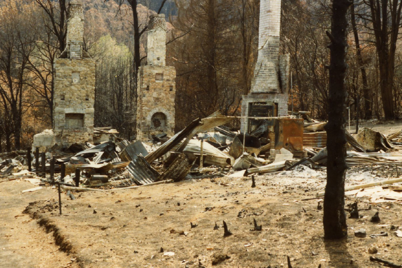
Remains of a house in Mount Macedon, Victoria after the Ash Wednesday bushfires in 1983 when 180 fires caused widespread destruction across Victoria and South Australia. Image: Wikipedia, reproduced under CC 2.0
When an amendment to the VPP is introduced at state level, all schemes across Victoria must be updated. Within this framework, local authorities develop local policy, apply the most appropriate zones and overlays and specify the content of schedules to some zones and overlays.
Within the VPP reform, the WMO was introduced. In the first version of the VPP (1997), wildfire protection was included at the strategic level (clause 15.07). The objective was to minimise risk through the Special Building Overlay (clause 44.07), which addressed areas susceptible to bushfire. This clause was substituted by the WMO (clause 44.06 (Amendment V3, 13 October 1997). As with all overlays, the WMO was based on mapping as a ‘permit required’ trigger, establishing an extra layer of requirement and consideration in addition to zoning. Its purpose was to identify areas where lives and properties are likely to be significantly threatened by bushfires and to ensure that development included specific fire-protection measures and did not significantly increase the bushfire threat to life and property. It triggered a permit to build in affected locations, establishing performance-based requirements of water supply, access, buildings and works (including siting) and vegetation; relating objectives and outcomes for them. Three references to consider when deciding on a permit application were provided, being:
- Design and Siting Guidelines, Bushfire Protection for Rural Houses (CFA and Ministry for Planning and Environment 1990)
- Planning Conditions and Guidelines for Subdivisions (CFA 1991)
- Building and Bushfire-Prone Areas – information and advice (Ramsay et al. 1993).
The WMO stipulated that the ‘Responsible Authority’ must determine whether a proposal satisfied relevant requirements or if it needed assessment by the relevant fire authority. The CFA was specified as the referral authority for subdivisions outside the Melbourne metropolitan fire district. The introduction of the WMO is an acknowledgement of the importance of land-use planning for mitigation; formally operationalising experience and knowledge about bushfire risk management. The WMO established a clearer framework and procedures to integrate CFA input into planning. However, planning applications were rarely, if ever, refused on grounds of bushfire mitigation measures and were regularly reduced or altered to facilitate other objectives such as vegetation retention. The incomplete mapping extent of the WMO limited its operationalisation. Mapping is critical to the implementation of bushfire risk management if it is to be the basis of statutory requirements. As detailed in the Victoria Bushfire Royal Commission report (Teague, McLeod & Pascoe 2010) the overlay was applied only to high-intensity fires in areas expected to be difficult to control instead of to all areas where bushfire was likely to threaten life and property. Each local council was responsible for adopting the WMO into their planning scheme. However, between 1997 and 2009, the WMO was applied to only 35 of Victoria’s 82 planning schemes. The criteria for mapping areas as WMO were inconsistent between local councils. In July 2002, the WMO mapping criteria applied by the CFA changed to the same criteria used to map the bushfire prone areas. However, there was no systematic re-examination of the mapping. In addition, the WMO was initially not applied to public land.
Reform and adjustment
In 2011, reforms and adjustments occurred and the WMO was replaced by the Bushfire Management Overlay (BMO). In 2014, there was an adjustment to the bushfire reforms to simplify and relax the planning requirements. These reforms were also accompanied by changes to the methodology used for mapping.
The 2011 Royal Commission was a trigger for bushfire urban planning change. The Black Saturday bushfires were the worst bushfire event in Australia’s recorded history. The Royal Commission (Teague, McLeod & Pascoe 2010) provided 67 recommendations, 19 of them regarding planning and building controls. Planning recommendations included to review the mapping criteria of the WMO and establish a single agency responsible for mapping, to substantially restrict new development in WMO and to set out CFA guidelines for assessing permit applications, among others.
These changes occurred within the context of growing institutional consensus that had occurred in the early and mid-2000s about the importance of using planning tools for disaster mitigation. For example, reports highlighted that land-use planning and development and building approval regimes that take into account disaster risk and mitigation are essential foundations for safer communities (COAG 2002). They indicate a need for greater liaison between planning and fire agencies at the local level and that there was poor and outdated spatial data (Parliament of the Commonwealth of Australia 2003). Ellis, Kanowski & Whelan (2004) argued that land-use planning ‘is the single most important mitigation measure for preventing future disaster losses (including from bushfires) in areas of new development’.
Consequently, VPP Amendment VC83 (18 November 2011) reformed the way statutory planning approached bushfire risk management. It introduced changes to policy, overlays and particular provisions and used a new logic that integrated planning and building. It replaced clause 13.05 ‘Wildfire’ with a new clause 13.05 ‘Bushfire’. The objective of this new clause was ‘to strengthen community resilience to bushfire’. It introduced the BMO, replacing the WMO (clause 44.06). The BMO set mandatory conditions, exemptions and general decision guidelines. Instead of providing specific application requirements, it mandated that applications meet requirements specified in clause 52.47: ‘Bushfire Protection: Planning Requirements’. Clause 52.47 established objectives, standards, mandatory standards and decision guidelines for the BMO. This included considerations for subdivisions, siting, bushfire protection, defendable space, water and access. The standards associated with the provision of defendable space were related to the requirements of the Building Act 1993 and AS3959 (Standards Australia 2009) and established integration between planning and building. The CFA role in the planning permit process and the BMO mapping process was strengthened by requiring that applications under the BMO be referred to the relevant fire authority that was the established ‘determining’ referral authority. Between 2009 and 2011, several amendments were made to facilitate reconstruction after the Black Saturday fires.
Since the initial introduction of the BMO, urban planning bushfire considerations have been adjusted, correcting and relaxing the 2011 reforms. VPP Amendment VC109 (31 July 2014) adjusted the requirements associated with the BMO and moved the application requirements from clause 44.06 to clause 52.47. The amended clause 52.47 introduced two pathways for compliance, being ‘approved measures’ and ‘alternative measures’ to meet the bushfire safety objectives. This eliminated the distinction between inner and outer defendable space, eliminating the outer zone and reducing the defendable space requirements. The status of CFA as the referral authority changed from ‘determining’ to ‘recommending’ referral authority (clause 66). While these changes were intended to facilitate development in constrained sites, their value has been contentious. The VPP Amendment VC140 (12 December 2017) amended clause 10 and clause 13.05, adjusting the policy focus to the prioritisation of human life over other policy considerations. Within the overall restructuration of the VPPs in 2018 (Amendment VC148) clauses were renumbered; from clause 10 to 71.02-3, from clause 13.05 to 13.02, from clause 52.47 to clause 53.02 and from clause 52.48 to 52.12). In addition, AS3959 (Standards Australia 2018) was updated in 2018, which simplified the site assessment procedure.
Associated with reform implementation, responsibilities for mapping were reallocated and the mapping criteria has changed several times. The Royal Commission (Teague, McLeod & Pascoe 2010) recommended that a single agency be responsible for establishing criteria for mapping areas at risk of bushfire instead of local councils determining if these areas should be included in their schemes. The Department of Environment, Land, Water and Planning is now responsible for mapping the BMO based on consistent criteria across Victoria. Furthermore, when the BMO was introduced, all WMO areas were automatically subject to the BMO. In August 2013, the mapping criteria were updated based on the Royal Commission’s recommendations and defined hazard mapping (not risk) be based on vegetation, topography and weather (Department of Planning, Transport and Infrastructure 2013). Draft mapping was prepared but did not proceed immediately. In 2017, the BMO mapping was updated across Victoria (Amendment GC13). The mapping criteria, developed by the Department of Environment, Land, Water and Planning, CFA and CSIRO, are vegetation type and size, ember buffer and extreme risk inclusions (Department of Environment, Land, Water and Planning 2017b).
Conclusions and next steps
This paper provides a chronological summary of the gradual integration of bushfire considerations into urban planning regulations. It traces the independent origins of planning and bushfire risk management, the emergence of bushfire risk management into urban planning, the formalisation of the integration of bushfire risk management via urban planning through the WMO and the reforms associated with the BMO. Over five decades there has been increasing emphasis on the integration of bushfire risk management into urban planning informing the ways of dealing with bushfires via urban planning.
In one way or another, losses have preceded regulation. In-depth inquiries after bushfire events have had a significant effect and instigated institutional and regulatory framework improvements. In addition, institutional and regulatory reforms have provided opportunities to incorporate previous bushfire knowledge and experience.
Current regulation delivers risk reduction benefits through urban renewal and disincentives to the renewal of existing housing due to the added cost of meeting regulation. However, limitations for dealing with bushfires via urban planning can also be identified. The urban footprint has largely been determined by development that occurred prior to bushfire regulation. The pre-regulation legacy poses continuing risks for future generations. The recent greater emphasis on human life protection is an attempt at redress. Integration between the building and planning instruments remains imperfect, while the referral-only role of the CFA could be strengthened. Local governments that are responsible for the bulk of implementation are often overworked and under-resourced for this role.