Urban settlements in bushfire interface areas face many ongoing challenges that require integrated actions across jurisdictional boundaries and spatio-temporal scales. The Charter for Fire Adapted Settlements (CFAS) and its practice note have been developed as a relatively simple summary of key principles to achieve this. Its foundational principles can be used and adapted in a range of settings in Australia and internationally to understand risks, to develop or critique existing processes and to take action.
Introduction
The management of bushfire1 risks in human settlements proximate to vegetated areas poses ongoing challenges. While dynamic change processes offer opportunities for action, many risks remain as ‘wicked’ and ongoing problems. As urban areas grow, associated demographic, socio-economic, transport and environmental pressures continue to emerge (McLennan and Handmer 2014). Further, establishing shared responsibility solutions that respond to associated climate change will prove increasingly difficult in the face of numerous competing demands (McCormack 2022) and diverse allocations of roles and responsibilities across public and private land.
This paper sets out CFAS as a common starting point for integrating understandings and actions in bushfire-prone settlements. First, challenges of managing bushfires in interface areas or peri-urban settlements are described, followed by a summary of the value of a charter. This paper sets out the methods used to develop a charter and its characteristics including an associated practice note.
The 12-page full charter is available online at: https://wildfirex.com.au/cfas-charter-for-fire-adapted-settlements/.
Challenges in bushfire interface settlements
Every year, more than 2 million small bushfire events are registered around the world. Most of them have no significant effects, yet a small proportion of them become very large incidents that have significant ecological and socio-economic consequences (Bowman et al. 2017). Bushfire frequency and intensity are increasingly associated with climate change and worsening weather conditions that result in extreme fires, a trend that is expected to continue (Jones et al. 2020). Expanding low-density urban sprawl and rural-residential developments are also contributing to increased exposure of people and assets to bushfires (Butt et al. 2009; Moskwa et al. 2018; Tedim, Xanthopoulos and Leone 2014).
Bushfire risk is typically highest in interface areas between vegetation and urban settlements where people, animals, property and infrastructure are more exposed to bushfire hazards. In these contexts, considerable variation of topography and vegetation, combined with diversity of possible and existing settlements, building characteristics and changing demographics means that there is no one fail-safe approach to risk reduction. The inter-jurisdictional nature of these interface areas and the physical and functional links between settlements and adjacent suburban and rural municipalities challenges bushfire risk management. Added to this, urban growth decisions made by councils pressured to provide land for new development, pay limited or late consideration to bushfires and other localised hazard risks can result in urban growth to areas exposed to bushfires.
Value of a charter
Settlements in bushfire-interface areas require management that considers the specific challenges posed. Charters have been used in a variety of ways. As detailed in Salem Press (2020), charters are grants of privilege, responsibility and process relating to management of places, governance and operations of agencies, businesses or the exercise of power. Well known charters include the Burra Charter relating to the identification and ongoing management of heritage places in Australia (ICOMOS 2013), the United Nations Charter (United Nations 1954) and the Magna Carter – the foundational ‘Great Charter’ upon which modern democracy rests (McKechnie 2022).
The CFAS acknowledges the challenges that face communities in bushfire-prone areas. It provides principles that cut across aspects of understanding, responsibility and action that hamper opportunities to reduce bushfire risks. It establishes ideals to critique current practice and sets clear understandings of processes.
Development of the CFAS
The CFAS was produced within Wildfire Exchange, an online learning hub for the development, exchange and consolidation of built environment bushfire knowledge between Chile and Australia. The charter’s development was an iterative process of design research that develops a product, in this case, the charter. It included 4 iterations.
The preliminary principles for fire-adapted settlements (Prototype 1) were established based on existing experience and a literature review covering 4 categories:
a) General context for assessing bushfire risk.
b) Dealing with bushfire risk in the built environment.
c) Places as part of networks and systems.
d) Governance systems for developing fire-adapted settlements.
Next, 2 online focus groups with the members of the Wildfire Exchange Steering Committee2 were conducted, one in Spanish for the Chilean members and the other in English for the Australian members. Participants were asked to discuss principles for fire-adapted settlements. Based on the focus groups data, preliminary principles were revised and a new prototype (2) was developed together with Practice Note 1. The practice note follows a similar approach to the Australian National Emergency Risk Assessment Guidelines (AIDR 2020) but includes the characteristics of bushfire-prone communities.
The revised charter and Practice Note 1 (prototype 2) were presented at the 2023 Australian Bushfire Building Conference where conference attendees could provide feedback. Prototype (3) was developed after this feedback.
Prototype 3 was presented at the seminar ‘Principios para la adaptacion de asentamientos frente al riesgo de incendios forestales’ (Principles for the Adaptation of Settlements to the Risk of Bushfires) organised by Wildfire Exchange in Santiago, Chile. A panel of experts was invited to discuss fire-adapted settlements from their areas of expertise and to provide feedback on the draft charter. The charter was revised into the final version (prototype 4).
In its final form, the CFCA addresses 4 principles:
- Establishing Context and Fundamentals.
- Managing Bushfire Risk in the Built Environment.
- Understanding Settlements as Part of Networks and Systems.
- Governance Systems for developing Fire Adapted Settlements.
Practice Note 1, which accompanies the CFAS, summarises procedural aspects of the charter.
The CFAS
The charter’s principles guide the design, occupation, management and governance of interfaces between vegetation and settlements. These principles provide a measure against which existing and future conditions can be understood and assessed. It is acknowledged that bushfire risk reduction includes other aspects that go beyond the scope of the charter, such as community education or ignition prevention. While the principles overlap across all stages, an ongoing and sequenced approach to achieving fire-adapted settlements is recommended.
Principle A – Establishing context and fundamentals
- Fire-adapted settlements are not overwhelmed by fire events. If property losses do occur, recovery significantly improves a settlement’s risk profile.
- Risk assessments are a prerequisite for decision-making. They are oriented to various uses by different decision-makers and users: to understand exposure, likelihood and consequences; to assist response; improve mitigation and resilience and reduce vulnerability. This might be focused on settlements, vegetation, ecological systems, populations or infrastructure and systems.
- Settlements intentionally and sustainably meet diverse human and natural system goals, including the implications of bushfires.
- Bushfires are expected in flammable landscapes, even if the fire return interval cannot be predicted.
- Future challenges are taken into account in risk assessment. Challenges might be heightened by climate change where more severe weather will occur. This may combine with changing demographics and settlement growth, large legacy stocks of older structures, and competing goals such as maintenance of habitat, biodiversity and limited resources.
- A common language of risk and associated terms exists and is used across disciplines to improve understanding and integration.
Principle B - Managing bushfire risk in the built environment
- Risk assessment in bushfire management involves potential consequences for human life, assets and the environment. This includes characteristics of place, including topography, physical attributes, ecological conditions, climate, cultural nuances and socio-economic factors.
- Risks are methodically deconstructed into constituent elements, addressing temporal scales ranging from daily dynamics to long-term perspectives. The multi-faceted nature of bushfire risk is assessed across spatial scales of large landscapes, settlement levels and individual sites, with a detailed understanding extending to road systems, precincts and entire settlements.
- Interactions between structures and flammable elements are considered. In addition to vegetation, this may include house-to-house transmission, outbuildings, fuel storage and urban morphology factors like road systems and the density of structures.
- Vulnerability of people, considering factors like age, ability, health, socio-economic status, experience and culture, is an interrelated resilience factor.
- The determination of ‘acceptable risk level’, grounded in considerations of risk equity, guides a systematic, transparent and prioritised approach to risk assessment and treatments over the short, medium and long terms.
- Exposure to bushfire hazard is generally reduced by separation of assets and people from fuels, modification of the hazard and improving structures against radiant heat, flame, embers, wind and tree strikes.
- High-risk settlements are prioritised, potentially requiring non-standard interventions, while urban planning avoids locating settlements or structures in high-risk areas.
The maintenance, retrofitting and improvement of existing structures are employed to reduce risks, with a focus on environmental respect and aesthetically pleasing solutions such as parklands, gardens, energy efficiency and enhanced community connectivity.
Principle C – Understanding settlements as part of networks and systems
- A whole-of-system approach to settlement function and risk reduction is undertaken, rather than reliance on limited elements such as response, vegetation clearing or building resistance.
- Bushfire is understood and treated as one of many co-occurring hazard events, such as drought, heatwave, atmospheric pollution and electrical and communications failures.
- Vegetation management is approached in an integrated manner. This includes integration across jurisdictional, ownership, spatial and other boundaries. It encompasses the challenging range of risk factors across habitat protection, silviculture, tourism, viticulture and cross-jurisdictional settlement risk.
- Fire-adapted settlements are equitable, connected, economically stable, healthy and informed, which allows appropriate self-determination, organisation and agency.
- Acknowledging the different stakeholders involved in risk reduction, systems are in place to provide landowners and residents risk assessments. This includes details of ‘ratings’ or treatments to existing or proposed structures, land or vegetation. A range of opportunities for knowledge and skill development are established.
Principle D – Governance systems for developing fire-adapted settlements
- Governance systems are in place to make decisions that reduce bushfire risks, including integration between government functions and the private sector, interest groups, communities and individuals. Integrated governance action includes laws and regulations that integrate evidence-based and forward-oriented actions.
- Growth and change are managed to bring about risk reduction benefits over time. Opportunities, whether small or large, are taken to reduce risks during new development of land, redevelopment, recovery processes, when land changes hands or when investments are made in the built environment.
- Place custodianship practices are recognised, encouraged and integrated where appropriate, including indigenous or other cultural aspects.
- Governance processes are fit-for-purpose and provide for information and data gathering as well as analysis and application to decision-making. Governance should manage bushfire risks including processes that allow assessment of trade-offs between individual property and development rights and collective risk-management outcomes.
- The ‘windows of opportunity’ that often exists after large events are used to reduce bushfire risk, typically based on prior work.
- The concept of shared responsibility guides actions and decisions. This means that all parties take full responsibility within their capacity to reduce bushfire risks. It also acknowledges that there are limits to responsibility.
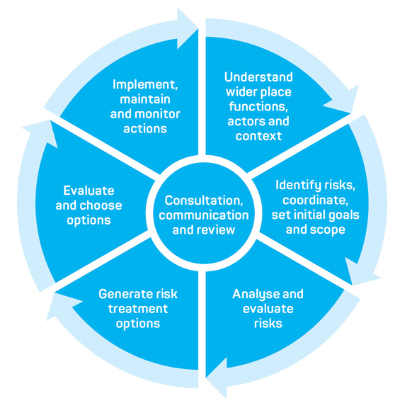
Figure 1: Charter for Fire Adapted Communities Practice - Note 1 process summary.
Practice Note 1 – Treating risk
The CFAS manages ongoing processes of change in a considered and integrated way. Practice Note 1 sets out the procedural stages of interrelated practice as illustrated in Figure 1. These steps are interpreted and applied according to circumstance. It adapts elements of the National Emergency Risk Assessment Guidelines (AIDR 2020). It can be used for a range of purposes, including developing understanding, procedural guidance, critique of existing settlements or of processes.
Understand wider place functions, actors and context
Understanding the functions and particularities of a settlement is an important first step. Each settlement has its own functions, characteristics, strengths and challenges that play a role in its resilience and ability to improve and change. It is useful to identify stakeholders, drivers, environmental conditions and demographics early in the process. It is also useful to establish initial aspirational goals for the community, often outside bushfire matters.
Identify risks, coordinate and set initial goals and scope
This phase identifies and coordinates stakeholders who have relevant information, roles, responsibilities and interests. In parallel, the scope and goals of the project are established as:
a) outcomes
b) spatial boundaries
c) targeted actions and scope
d) time periods
e) resources and responsibilities
f) context of other processes and influences.
Risk identification requires bushfire risks to be established and described, usually iteratively. The CFAS process assesses the wider risk environment but primarily understands risk from the perspective of the settlement, being:
a) the bushfire hazard
b) potential effects
c) current treatments and processes
d) elements at risk such as people, the environment, structures and infrastructure
e) consequences of potential bushfire interactions with the settlement.
Risks are identified with a spatial and physical aspect and in association with human and environmental elements. This includes mapped, tabulated and scenario-based descriptions at various scales of:
a) vegetation
b) fire history
c) topography, access, places of refuge, water sources
d) settlement characteristics such as morphology and structures’ resistance
e) likely fire behaviour and interactions with the settlement
f) likely consequences.
Analyse and evaluate risks
Risk levels are determined by analysing the consequences and likelihoods of fire events. If a given fire event occurred, the outcome is described as the consequences to people, structures, economy, environment and community. Likelihood is the chance of the consequence occurring. In fire-prone settlements, likelihood is considered over extended periods such as 100 years. This would include factors such as growth forecasts and climate change. The relatively ‘fixed’ built environment assumes that worst-case fires will occur at least once during a structure’s or a settlement’s lifespan.
Risk analysis is undertaken by determining the likelihood and consequences and establishing a risk level for all appropriate scenarios. These will be spatially mapped. Evaluation of risks allocates priorities. A CFAS evaluation includes a spatial, mapped and tabulated approach to facilitate prioritisation.
Generate risk treatment options
Generation of risk treatment options is challenging. Nonetheless, deliberate integration of multiple objectives in parallel with bushfire risk reduction is a fundamental goal. Scenario and strategic planning are central to this. There are 2 steps in this process:
1. Develop objectives for risk treatment.
3. Develop options for risk treatment covering:
- separation of structures from bushfire
- hazard modification
- improved resistance
- improved response
- improved recovery.
Importantly, the options developed will be spatial, regulatory, economic, educational and environmental, associated with overarching settlement change.
Evaluate and choose options
There will be a need re-establish the objectives set out in the beginning of the process. Risk treatment options chosen should prioritise primary causes over superficial symptoms. It is necessary that process and governance systems are in place, or are put in place, to facilitate the effective and legitimate selection of risk management options.
Implement, maintain and monitor actions
Processes of risk treatment will be ongoing and will require integration of activities across functional jurisdictions. These will include urban planning; building; forestry; transport; natural resource management; municipal, state and other agencies; developers or other interest groups (see also AIDR 2020).
Ways forward
Future and present challenges are likely to be heightened in the context of climate change, where severe weather will be more frequent, combined with changing demographics, ongoing growth of human settlements and land use. The possibility that communities can live and prosper in bush interface areas vulnerable to fire presents opportunities and challenges. This research sets out principles for fire-adapted communities. It also acknowledges that many places will require a transformational change to become fire-adapted but will realise the benefits that come from bushfire risk assessment and risk treatments.